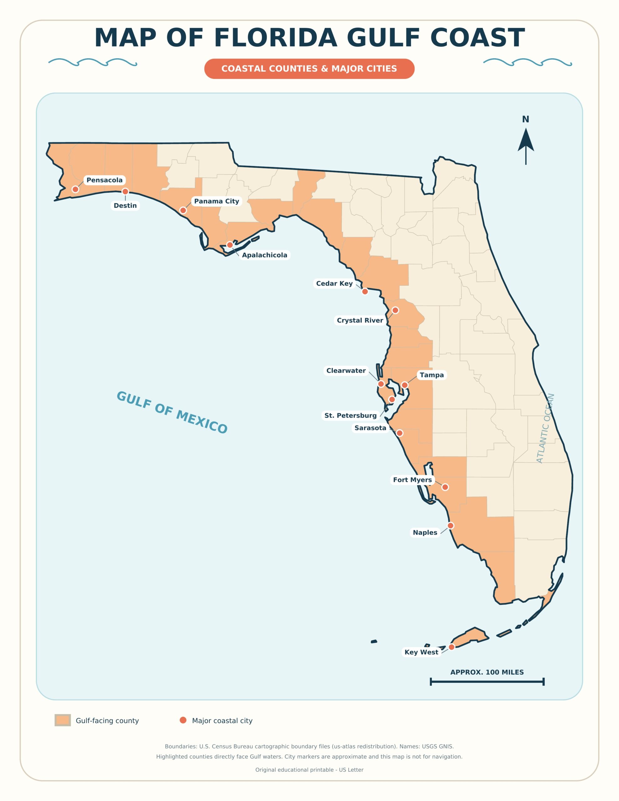
Map of Florida Gulf Coast — Use the labeled map below to locate the major cities, beach destinations, islands, bays, and travel corridors along Florida’s western shoreline. The printable is available as a high-resolution JPG for viewing or saving and as a one-page PDF for convenient printing.
Florida’s Gulf Coast stretches from the western Panhandle near Pensacola to the subtropical shoreline of Southwest Florida. It includes very different destinations: the emerald-colored water and dune-backed beaches of Northwest Florida, the urban waterfronts around Tampa Bay, the barrier islands near Sarasota and Fort Myers, and the mangrove-rich coast near the Everglades. Because “Florida Gulf Coast” can refer to this entire shoreline or only the peninsula’s west coast, this map provides a broad statewide view.
Download the Map of Florida Gulf Coast PDF
Download the High-Resolution JPG
What Does the Florida Gulf Coast Map Show?
The map is designed as a practical geographic reference rather than a turn-by-turn navigation chart. It helps readers understand where the best-known Gulf Coast regions sit in relation to one another. Major destinations shown or represented include Pensacola, Destin, Panama City, Apalachicola, Cedar Key, Clearwater, St. Petersburg, Tampa, Sarasota, Fort Myers, Naples, and Marco Island.
It also provides context for important coastal waters and natural features, including the Gulf of Mexico, Tampa Bay, Charlotte Harbor, barrier islands, and the northern edge of the Everglades region. Major highway corridors are included to make the map more useful for early-stage trip planning.
Florida Gulf Coast Regions from North to South
Pensacola and the Western Panhandle
The western end of Florida’s Panhandle begins near the Alabama state line. Pensacola and Pensacola Beach are among the most recognizable destinations in this area. Farther east are Navarre Beach, Fort Walton Beach, Destin, and communities along the scenic coastal corridor.
This part of the coast is often called the Emerald Coast, a name associated with its green-blue water and pale sand. The shoreline is much closer to southern Alabama and Mississippi than it is to Central or South Florida, which is important when estimating driving times.
Panama City and the Forgotten Coast
Panama City Beach sits east of Destin and is one of the Panhandle’s best-known vacation areas. Continuing east brings travelers toward Mexico Beach, Port St. Joe, Cape San Blas, Apalachicola, and St. George Island.
The quieter stretch around Franklin, Gulf, and Wakulla counties is commonly associated with the Forgotten Coast. Compared with the large resort areas farther west, this region has smaller communities, protected landscapes, estuaries, and working waterfronts.
Big Bend and Nature Coast
Florida’s Big Bend is the curved shoreline where the Panhandle transitions into the peninsula. It contains broad marshes, river mouths, wildlife habitat, and fewer continuous sandy beaches than the Panhandle. Coastal communities and access points include places near Steinhatchee, Horseshoe Beach, and Cedar Key.
The Nature Coast extends through parts of the Big Bend and west-central Florida. Crystal River, Homosassa, and nearby spring-fed waterways are notable features. Visitors should understand that the landscape here often consists of marshes, tidal creeks, and limestone-influenced waterways rather than long resort beaches.
Tampa Bay, Clearwater, and St. Petersburg
The Tampa Bay area is the largest urban region on Florida’s Gulf side. Tampa lies on the bay, while St. Petersburg occupies the Pinellas Peninsula between Tampa Bay and the Gulf. Clearwater and Clearwater Beach are north of St. Petersburg, with additional barrier-island communities extending along the coast.
This region combines urban attractions with popular beaches. Bridges and causeways connect the communities around Tampa Bay, so a place that looks close on a map may require a longer drive around water or across a heavily traveled bridge.
Sarasota, Bradenton, and the Barrier Islands
South of Tampa Bay are Bradenton, Anna Maria Island, Longboat Key, Sarasota, Lido Key, and Siesta Key. According to Florida’s official tourism information, Siesta Key is a barrier island off the Sarasota coast and is known for its bright quartz sand.
Farther south are Venice, Englewood, and the shoreline around Charlotte Harbor. This portion of the coast is useful for travelers seeking a combination of beaches, walkable island communities, boating, and access to cultural attractions in Sarasota.
Fort Myers, Sanibel, and Captiva
The Fort Myers area sits near the Caloosahatchee River and includes access to Fort Myers Beach, Sanibel Island, Captiva Island, Cape Coral, and Pine Island. Sanibel and Captiva are barrier islands, and road access can be affected by bridge traffic, weather, maintenance, or temporary local restrictions.
Always verify current beach, causeway, and park conditions before traveling. A printable overview map is helpful for orientation, but live navigation and official local advisories should guide the actual journey.
Naples, Marco Island, and the Everglades
Naples and Marco Island anchor the southwestern portion of Florida’s Gulf Coast. South and east of these communities, the landscape transitions into the Ten Thousand Islands and the Everglades ecosystem. Roads become less numerous, and many coastal areas are reached primarily by boat.
Everglades City provides access to waterways and protected landscapes, but it should not be treated like a typical Gulf beach resort. The region is environmentally sensitive and contains extensive mangroves, shallow bays, islands, and wildlife habitat.
Best Ways to Use This Printable Map
- Vacation planning: Compare the relative locations of Panhandle, Central Gulf Coast, and Southwest Florida destinations.
- Road-trip planning: Mark overnight stops and divide a long coastal route into manageable sections.
- Classroom geography: Identify Florida’s peninsula, Panhandle, Gulf shoreline, major bays, and coastal cities.
- Travel binder: Print the PDF and add notes for hotels, parks, restaurants, and planned activities.
- Wall or bulletin-board display: Use the high-resolution JPG for a larger visual reference.
How to Print the Florida Gulf Coast Map
- Open the downloadable PDF rather than printing the website image.
- Select US Letter paper and landscape orientation.
- Choose “Fit,” “Fit to printable area,” or a similar option in the print dialog.
- Use color mode for the clearest distinction between water, land, roads, and labels.
- For a reusable travel copy, place the page in a clear sleeve or laminate it after printing.
The JPG is better suited to screens, presentations, and image-based projects. The PDF generally produces more predictable sizing on a home or office printer.
Important Map and Travel Limitations
This printable is an educational and trip-planning overview. It is not a nautical chart, emergency evacuation map, parcel map, flood-zone map, or real-time road map. Coastlines, inlets, beaches, and access conditions can change. Road closures, storm damage, construction, water conditions, and park availability should always be checked using official or live sources.
Do not use this map for marine navigation. Boaters should use current official nautical charts and required navigation equipment. During tropical weather, follow county emergency-management instructions and official evacuation information.
Frequently Asked Questions
Where does Florida’s Gulf Coast begin and end?
In the broadest geographic sense, it runs from Florida’s border with Alabama in the western Panhandle around the state’s western shoreline toward Southwest Florida and the Florida Keys. Travel guides sometimes use “Gulf Coast” more narrowly for the west coast of the peninsula.
What are the main cities on Florida’s Gulf Coast?
Frequently referenced cities and destinations include Pensacola, Destin, Panama City, Tampa, Clearwater, St. Petersburg, Bradenton, Sarasota, Fort Myers, Naples, and Marco Island. Some cities, such as Tampa, are located on bays connected to the Gulf rather than directly on an open Gulf beach.
Is Tampa directly on the Gulf of Mexico?
Tampa is located on Tampa Bay, which connects to the Gulf of Mexico. Gulf-facing beaches are found primarily west of Tampa, especially along the Pinellas County barrier islands and nearby coastal communities.
Which side of Florida has Gulf beaches?
The Panhandle and western side of Florida face the Gulf. The state’s eastern shoreline faces the Atlantic Ocean. South Florida contains areas where these broader marine regions transition toward the Florida Straits.
Is this Florida Gulf Coast map free to print?
Yes. You can download the provided PDF for personal, classroom, or noncommercial travel-planning use.
Sources and Map Notes
The geographic presentation was prepared using public cartographic reference data and cross-checked against official destination information. For current visitor guidance, see VISIT FLORIDA’s Gulf Coast beach guide and its Florida places directory. Always verify live road, weather, beach, and park conditions before departure.