Oregon Wildfire Map 2026 — This page provides a dated overview of selected publicly reported wildfire perimeters in Oregon, plus direct links to official live dashboards. The printable map below is a snapshot from July 27, 2026; it is not a real-time evacuation map. The closely related phrase “Oregon fires map” is covered on the same page.
Wildfire information can change within minutes as crews improve mapping, weather shifts, or local authorities change evacuation zones. Use this page for statewide orientation and education, but use emergency alerts, county sheriff instructions, and official state fire dashboards for personal safety decisions.
Download the Printable PDF Map
Download the High-Resolution JPG
Current Oregon Wildfire Map Snapshot
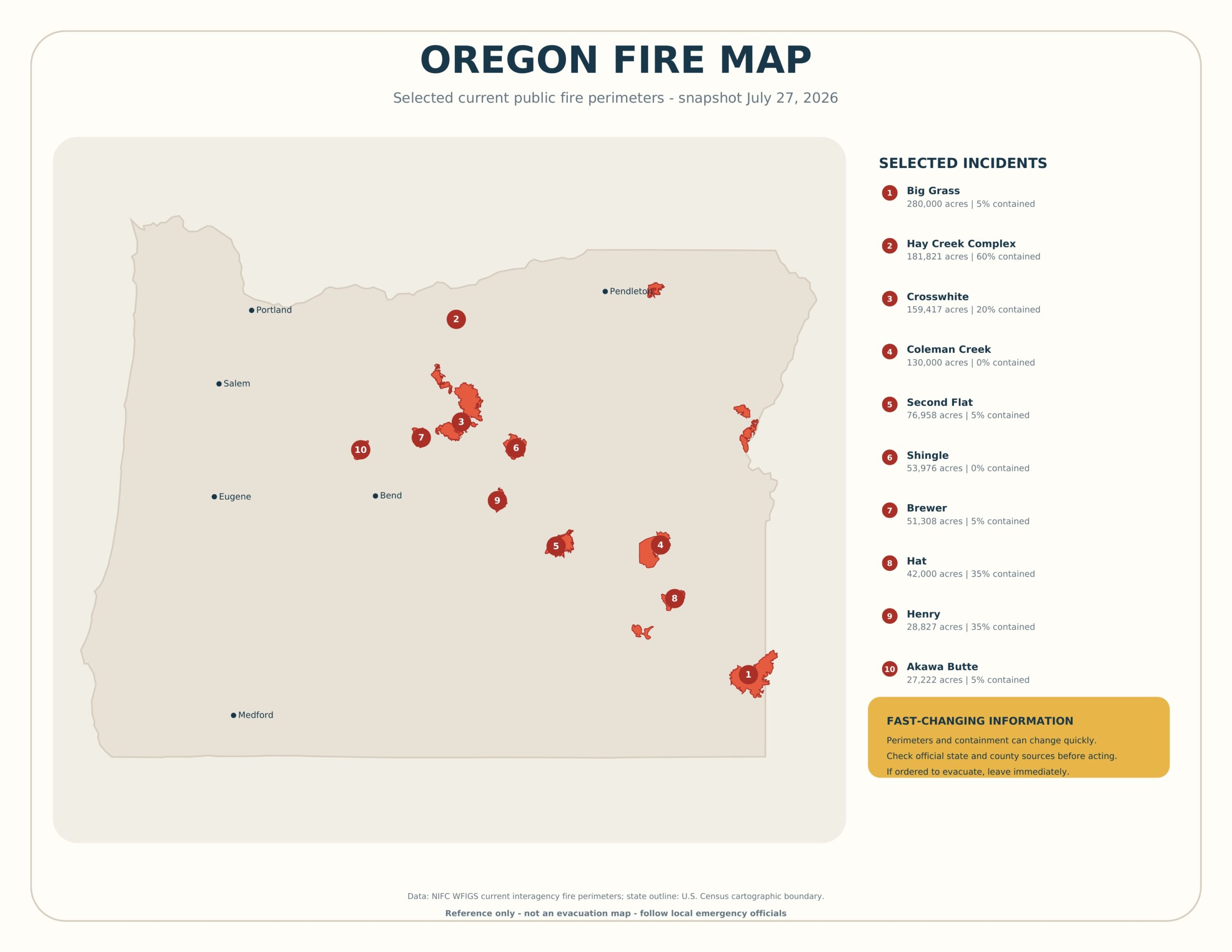
The map highlights selected incidents with current public perimeter geometry in the National Interagency Fire Center’s WFIGS dataset. To keep labels readable, it prioritizes larger or otherwise notable perimeters and does not attempt to display every smoke report, prescribed burn, small initial-attack incident, or fire without a published perimeter.
- Big Grass — 280,000 reported acres and 5% reported containment; point-of-origin county: Malheur.
- Hay Creek Complex — 181,821 reported acres and 60% reported containment; point-of-origin county: Gilliam.
- Crosswhite — 159,417 reported acres and 20% reported containment; point-of-origin county: Wheeler.
- Coleman Creek — 130,000 reported acres and 0% reported containment; point-of-origin county: Harney.
- Second Flat — 76,958 reported acres and 5% reported containment; point-of-origin county: Harney.
- Shingle — 53,976 reported acres and 0% reported containment; point-of-origin county: Wheeler.
- Brewer — 51,308 reported acres and 5% reported containment; point-of-origin county: Jefferson.
- Hat — 42,000 reported acres and 35% reported containment; point-of-origin county: Malheur.
- Henry — 28,827 reported acres and 35% reported containment; point-of-origin county: Crook.
- Akawa Butte — 27,222 reported acres and 5% reported containment; point-of-origin county: Jefferson.
Important: Acreage and containment are time-stamped reported values, not guarantees. Containment is the portion of a fire perimeter where crews believe spread has been stopped or checked; it does not mean the fire is extinguished or that an area is safe to enter.
How to Use the Live Oregon Fire Map?
- Open the official statewide dashboard before making travel or safety decisions.
- Zoom to your county and identify the incident name nearest your location.
- Check the incident’s last-updated time, reported perimeter, and available public notes.
- Open the county emergency-management or sheriff page for evacuation zones and road restrictions.
- Check air-quality and transportation sources separately because smoke and closures may extend far beyond a fire perimeter.
For the latest information, use the Oregon State Fire Marshal wildfire dashboard. A second useful official resource is the Oregon Department of Forestry.
What the Symbols and Perimeters Mean
A fire perimeter represents the best available mapped boundary of a reported incident at a particular time. It may be created from aerial infrared imagery, GPS observations, satellite information, or other approved mapping methods. It is not necessarily identical to an evacuation boundary, smoke footprint, closure area, or prediction of where the fire will move.
The numbered circles on this printable correspond to the selected incident list. City labels are included only for geographic orientation. An incident can cross county, tribal, state, or agency boundaries even when the point-of-origin field names only one county.
Why the Fire Map May Not Match What You See?
- Mapping delay: A newly active edge may not appear until new perimeter data is approved.
- Smoke displacement: Wind can transport smoke hundreds of miles from its source.
- Different update schedules: Incident pages, dashboards, satellites, and county alerts may refresh at different times.
- Perimeter availability: Not every fire has a public polygon.
- Complex incidents: A complex can contain multiple named fires or merged perimeters.
Wildfire Evacuation Levels and Alerts
Many western jurisdictions use three escalating evacuation levels, commonly summarized as “Ready,” “Set,” and “Go,” although exact terminology and instructions can vary. Level 1 generally means prepare, Level 2 means be ready to leave quickly, and Level 3 means leave immediately. Always follow the wording issued by your local authority rather than relying on a general definition.
Do not wait for the printable map to change. If officials issue an evacuation order, follow the specified route and leave promptly. Keep phones charged, maintain fuel, bring medications and identification, and account for children, older adults, pets, and livestock.
Wildfire Smoke, Roads, and Air Quality
A fire perimeter shows burned or burning area, not the full smoke impact. Sensitive groups may experience symptoms far from an incident. Use AirNow or your state environmental agency for current air-quality readings. For highway closures, consult the state transportation department rather than assuming a road is open because it is outside the mapped perimeter.
How to Print the Oregon Fire Map?
- Download the PDF using the button above.
- Select US Letter paper and landscape orientation.
- Choose “Fit” or “Fit to printable area.”
- Print in color so perimeter shading and numbered markers remain clear.
- Write the snapshot date on any copy retained for later reference.
Frequently Asked Questions
Is this Oregon fire map live?
No. The JPG and PDF are a snapshot from July 27, 2026. Use the linked official dashboard for updated information.
Does the map show evacuation zones?
No. A fire perimeter and an evacuation zone serve different purposes. Check county emergency alerts and law-enforcement notices for current evacuation boundaries.
Why is a nearby fire missing?
The printable shows selected incidents with available public perimeter data. New fires, small fires, prescribed burns, or incidents awaiting approved geometry may not appear.
Can I use the map for route planning?
Only for broad orientation. Use live transportation information, closure notices, and directions from emergency officials before traveling near a wildfire.
Is the PDF free to print?
Yes. It is provided for personal, classroom, newsroom, and noncommercial reference use.
Sources and Update Policy
The snapshot uses public NIFC WFIGS interagency perimeter data and U.S. Census cartographic state boundaries. Current operational decisions must come from local emergency officials and the official Oregon resources linked above. The printable should be replaced whenever a newer dated edition is published.