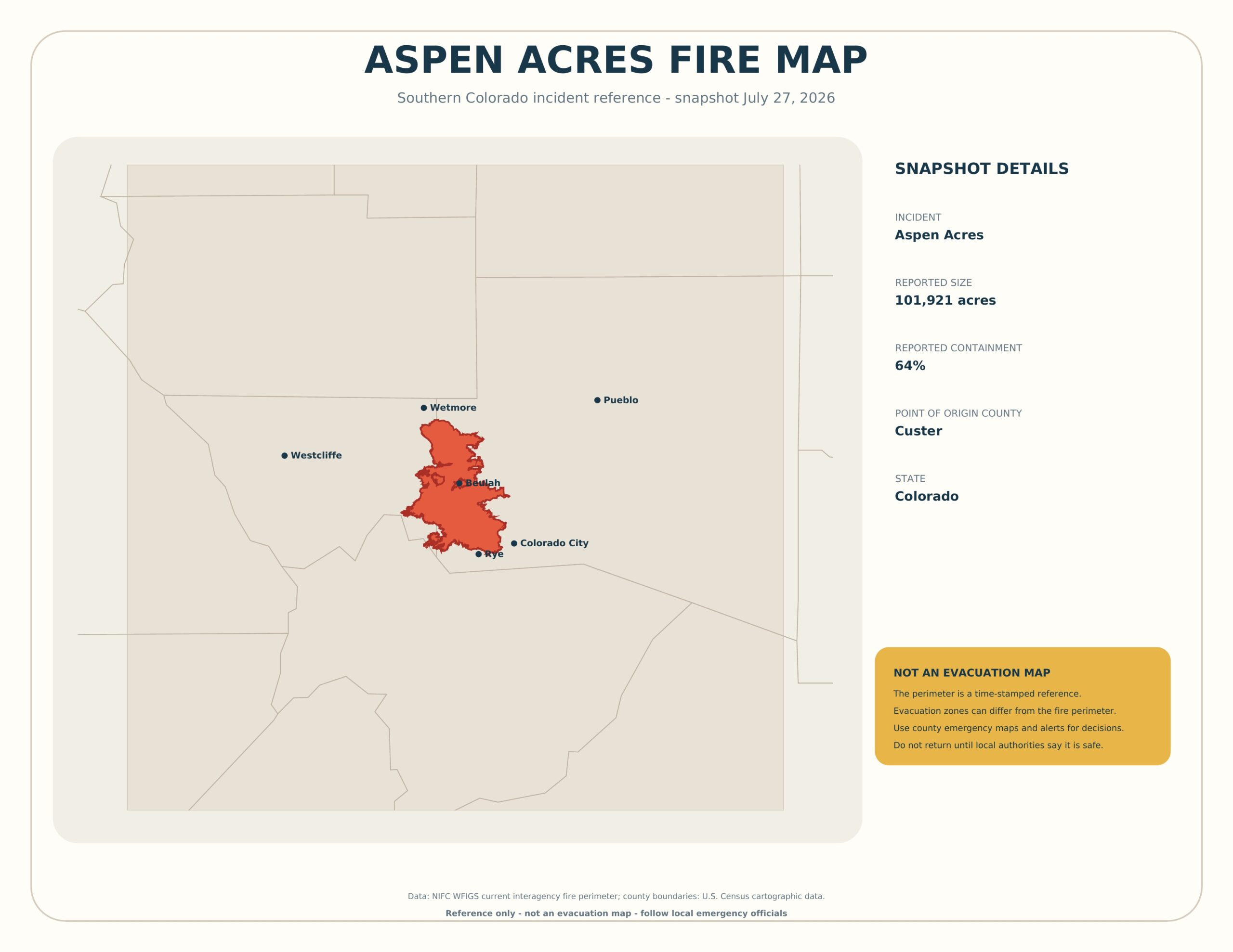
Aspen Acres Fire Map 2026 — The map below shows the best available public perimeter for the Aspen Acres Fire in southern Colorado as a dated reference. The NIFC WFIGS record used for this edition reported approximately 101,921 acres and 64% containment. Those figures can change, so always check current incident and county emergency sources.
The fire began in Custer County and affected a broader multi-county area. A fire perimeter shows mapped fire extent; it does not automatically show evacuation zones, property damage, open roads, safe return areas, or the direction in which the incident may spread.
Download the Printable PDF Map
Download the High-Resolution JPG
Aspen Acres Fire Map Snapshot
- Incident name: Aspen Acres Fire
- State: Colorado
- Point-of-origin county: Custer
- Reported size in this snapshot: 101,921 acres
- Reported containment in this snapshot: 64%
- Printable snapshot date: July 27, 2026
These values describe the source record used to create the printable. They should not be quoted as current without checking the latest incident update.
Where Is the Aspen Acres Fire?
The incident is in southern Colorado, with its point of origin recorded in Custer County. The broader impact area has involved communities and jurisdictions across Custer, Pueblo, Fremont, and Huerfano counties. Nearby reference points on the map include Westcliffe, Wetmore, Rye, Beulah, Colorado City, and Pueblo.
A named community appearing near the perimeter does not prove that every address in that community burned or remains under an evacuation order. Always use address-level county tools and official emergency notifications.
How to View the Current Aspen Acres Fire Map?
Use the official InciWeb incident page for federal incident information. For local impact and evacuation mapping, open the Custer County Aspen Acres Fire information map.
- Check the last-updated time on the page or map.
- Confirm whether you are viewing a fire perimeter, evacuation zone, closure, or damage-assessment layer.
- Search for your address only in a tool designed for address-level emergency information.
- Follow county sheriff and emergency-management instructions.
- Do not return to an evacuated area until authorities announce that it is safe.
What the Fire Perimeter Means?
The perimeter is a mapped polygon representing the best available boundary of the incident at a particular time. It may be updated after aerial infrared flights, field mapping, or other approved observations. Some areas inside the polygon may have burned at different severity, and islands of unburned vegetation can remain within a perimeter.
The perimeter is not a forecast. Wind, fuels, terrain, and suppression actions can affect fire behavior beyond the last mapped edge.
Containment Does Not Mean Extinguished
Containment describes the portion of the perimeter where control lines or natural barriers are expected to stop spread under anticipated conditions. A fire can continue burning inside containment lines. Smoke, hot spots, falling trees, utility damage, and restricted access may remain after reported containment increases.
Evacuation Zones vs. Fire Perimeter
Evacuation zones are created to protect people from expected hazards and may extend well beyond the mapped fire edge. They can incorporate roads, terrain, wind forecasts, limited escape routes, and firefighting operations. For that reason, never use the printable perimeter to decide whether to stay, leave, or return.
Road Closures, Smoke, and Reentry
Road closures may be imposed for active fire behavior, debris, damaged guardrails, utility repairs, emergency vehicles, or law-enforcement operations. Smoke can reduce visibility far outside the perimeter. Reentry can occur in phases, and some properties may remain inaccessible after a wider evacuation order is lifted.
How to Print the Aspen Acres Fire Map?
- Download the PDF rather than printing the website preview.
- Select US Letter paper and landscape orientation.
- Choose “Fit to printable area.”
- Print in color so the perimeter remains visible against county boundaries.
- Keep the snapshot date visible and discard outdated emergency copies.
Frequently Asked Questions
Is this Aspen Acres Fire map live?
No. It is a snapshot created from a public perimeter available on July 27, 2026. Use official incident and county tools for updates.
Does the red area show destroyed properties?
No. It shows the reported fire perimeter, not a structure-damage assessment.
Does containment mean the fire is out?
No. Fire can remain active inside containment lines, and hazards can continue after growth slows.
Can I check my address with this printable?
No. Use an official address-level emergency or damage-assessment map when available.
Is the map free to print?
Yes. It is available for personal, classroom, newsroom, and noncommercial reference use.
Sources and Safety Notice
The perimeter and incident attributes were obtained from the public NIFC WFIGS current interagency fire-perimeter service. County geometry comes from U.S. Census cartographic data. For emergency decisions, rely on InciWeb, county emergency management, sheriff alerts, and official evacuation instructions—not this printable.